The 10 minute Quick Guide to Flying Fort Funston
Click or Tap the pictures for a larger image.
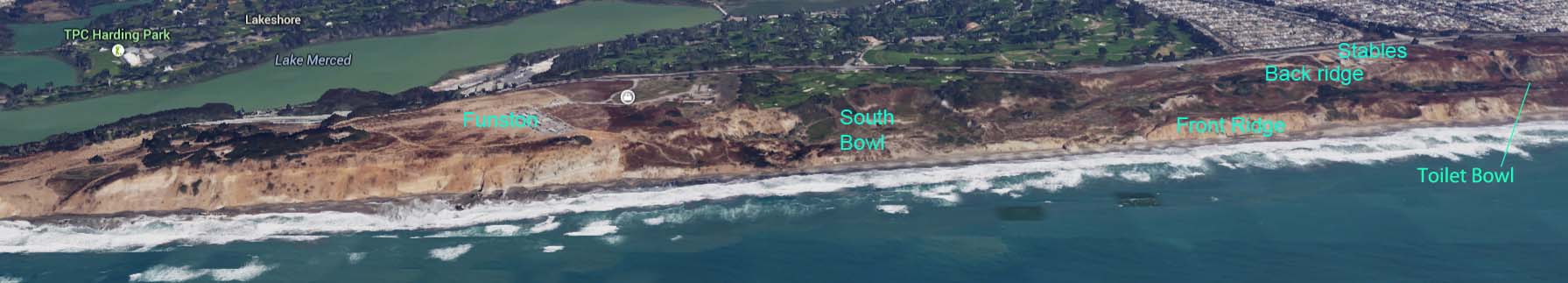
This guide is ordered from most to least important – for those of you with ADHD who won’t make it to the end. This guide is not meant to cover all the rules of the Fellow Feathers Hang Gliding Club – see the FF Club Rules. On light wind days, the flying is only from launch north to the North Gap. As it gets stronger the South Bowl becomes accessible. You’ll want to get 100-200′ over to try for Westlake.
Local Pilots
If you are not familiar with the area, connect with local pilots to get a site overview. If you are a new H3, be prepared to demonstrate a launch, short flight, and landing to a local pilot BEFORE being approved to fly unsupervised.Birds
Watch them – they know a LOT better than you how good the conditions are. See how high they are, and whether they are flapping (that means no lift).Windsock
Your best wind indicator for what’s happening at the cliff. If there is a kink in the middle, it’s marginal. If it’s pointing straight back at the camera, it’s pretty much straight in.Winds
If over 30, forget it. Sometimes marginally flyable as low as 8. Keep in mind the performance range of your glider, and if it’s light it may get crowded. If the wind is picking up sand, its over 30.West
Or straight in – from 8-30mph, launch is easy – landing also easy – anywhere in main LZ ok.West South West to South West
Move to the left more to launch. Landing super easy. Best approach is from the north heading south, turn AFTER the beginning of the bushes, go over bushes, do another slight turn into the wind to land. Start too early you may end up in the parking lot. Not good. If you decide to go past launch & do a 270 degree turn, keep in mind you’re inside (left) wing will be going much slower – DON’T STALL IT. Keep speed up & pull in as you go downwind! If its strong SW, you’re not likely to make it to Westlake.West North West to North West
Tricky! Often it’s strong. If over 25, don’t recommend it. Also LZ will be in bush rotor. Watch the streamers!! If the south corner streamers by the bushes are staying steady, that’s the best bet. Come in HOT, get into ground effect, and just wait for speed to bleed off. FEEL THE WIND, not the groundspeed – if there is a strong gradient, you may need to flare sooner than usual. Option the corner over by the clubhouse – but note you will have to fly through the bush rotor at about 50′ to get to it. Don’t let it scare you, come in hot, get into ground effect & bleed it off. If it’s strong NW, you may make it to Westlake, but not be able to get back. If the winds get too strong and your not comfortable doing the top landing, opt for the beach. Call up – someone will bring down your bag and help you carry up.Launch
TIGHT HANG STRAP! Can’t say it enough. If it’s strong and straight in there’ll be a little down 20′ or so back from cliff edge. On NW days, keep left wing low and glider pointed into wind. You may find it easier to crab – glider pointed into the wind, but run straight off. The left wing WILL tend to come up as it gets into the lift band. Use wire help if you think you need it BEFORE you get out there. Non-pilots are not allowed in the area immediately behind launch while launching – ask them to move behind the cones until you’ve cleared launch. Tides – check how much beach there is. There’s almost always some way to land on the beach, but you might want to reconsider flying on very high wave/high tide days in marginal conditions. DO NOT LAND IN THE WATER OR WHERE WAVES REACH! You may want to carry a hook knife to cut yourself out of your glider if necessary.Landing
Check wind sock – what direction is it? Has it changed since you launched? Check the streamers – see which ones are consistent. Keep your head swiveling! Don’t ignore other pilots just because you’re checking out the LZ. If you’re not sure, come in hot, with plenty of speed, dive down to ground effect level, then bleed off speed in ground effect. Many try to parachute in on easy days – this is deadly on NW days – I’ve seen several badly broken gliders & pilots from making this mistake. Bush rotor – the entire area downwind of the bush around the observation deck is usually turbulent – make a mental picture of where it is flowing and avoid this region. Plan your landing well clear of pedestrians – especially on weekends there is a steady stream heading between the parking lot & the beach trail. Note trail areas on the top view – light colored paths. Current rule is 25′ clearance. Don’t linger in the LZ! On busy days others may be waiting to land. Land and move to the setup area ASAP. Common landing approaches and the Bush rotor in a North West wind. Click & hold to pause animation at any time.Setup Area
When setting up or after parking your glider behind the bush, keep an eye on the wind direction. Park your glider pointing towards the bush. Winds should blow across or from behind your gider. Often winds will shift during the day & a location that is fine at one time will lift a wing later. Also, please be courteous and leave room for others to get out. If you have wheels, make sure you can’t roll into other gliders!
Soaring Ridge Rules
- Pilots lower than you always have right of way.
- When near the same level, and two pilots are flying towards one another on the ridge, the pilot with the ridge on his/her right side has right of way
- When flying in the same direction, and over taking another pilot, the pilot on the inside has right of way.
Clubhouse Wind Direction & Speed Adjustments
On WSW to NW days, multiply the wind speed on the graph by 1.25 to get the true speed at the cliff. If it’s reading 24 it’s probably closer to 30. If the wind is SW, the speed is erratic and may read way too low – the south hill by the ranger station affects the speed. If the direction is shifting around a lot (going SW then NW), it’s likely the back side or the edge of a shear – and VERY turbulent. Note the gust speeds too.Westlake
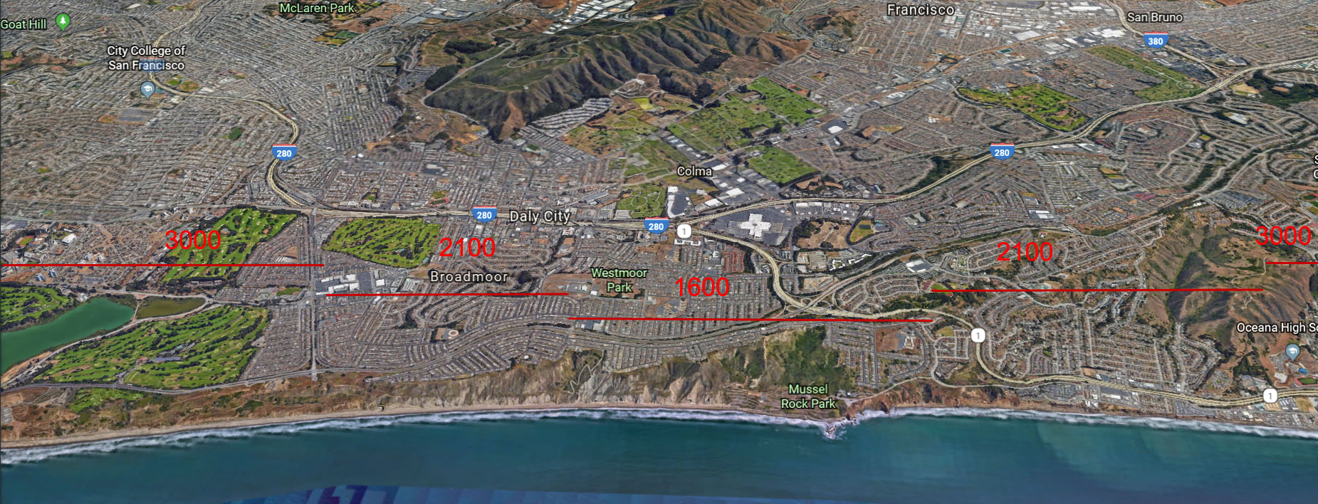
To get there, you’ll need conditions of 15+ and not SW. There are 2 tricky areas – after you get past the south bowl and cross over to the lower or back ridge, and just before you get to where the Westlake ridge starts to climb. If you don’t have 100′ or over best to not try it. DON’T take the back ridge on SW days – the area just before the rise at Westlake will have a NASTY rotor. If you’re getting below ridge level anywhere along here I strongly suggest you turn around and head back – you’ll likely end up on the beach anyway but it’ll be a LOT shorter walk than if you kept going. Once you hit the area where the ridge start to climb, usually you’ll be fine. Work the area north of the gap to get high, then you can jump the gap and play at the dumps. Ceiling is 2100′ north of gap, 1500′ south of it.
Cloud Ceiling
Many of the best flying days also have a cloud ceiling that may extend anywhere from a few feet over launch to a few hundred feet over Westake. Stay out of the clouds (so other pilots can see you). Be aware that moisture can build up on your wing & downtubes and change the flying characteristics of your glider. Wear gloves with strong grip fingers that won’t slip on the downtubes when landing. Best way to judge from the ground the ceiling height is to look south towards Westlake and see where it whites out.Death Bowl & Parts South
Don’t go there unless you’ve got a few hundred hours of experience flying the dumps.Shears
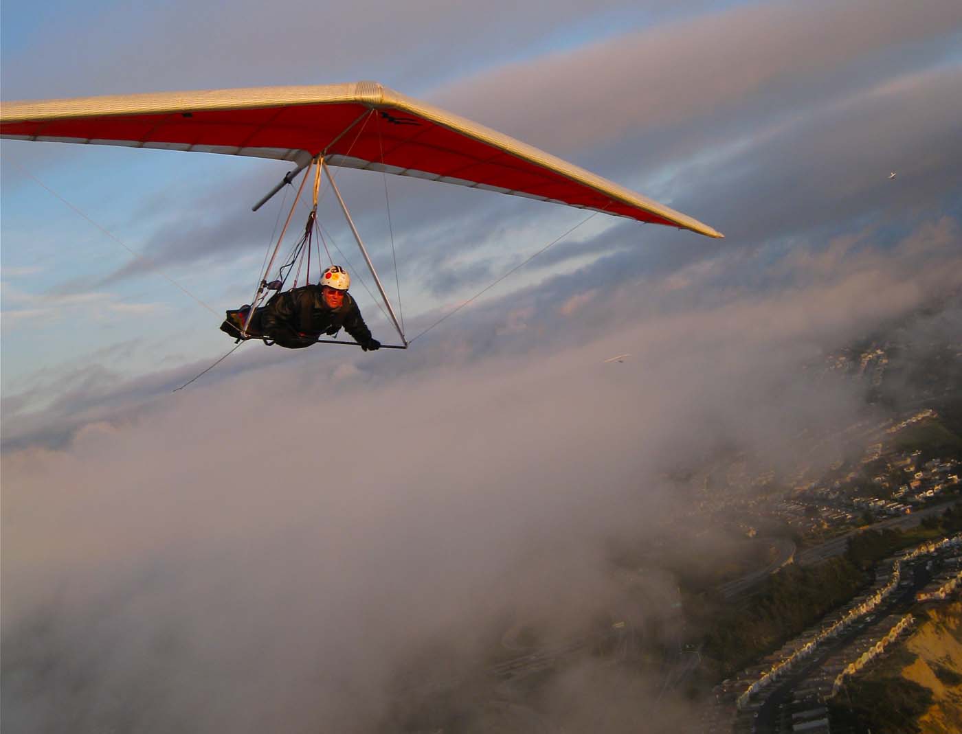
The mythical magical Funston Shear. By far the most common is the NW shear. Sets up often in spring, and fairly often through summer & occasionally after a storm in fall. The telltale as the shear is approaching is light, switchy W to SW winds, but a strong NW on the buoys.
see: http://www.lajollasurf.org/nocal.html )
Notice the SF & the Pt Reyes buoy. If they are strong NW & Funston is SW then there is a shear there – it’s just a question of where the line is. NOAA defines a shear where wind changes speed and/or direction with height. At Funston it is more typically two air masses moving in different directions. It can also appear and act like a wave. The boundary region or shear line between the two air masses is typically turbulent. At ground level it may be warm and SW, out on the water it’s cold and strong NW. As the shear line approaches, there will be white caps past the shear line, but probably NO whitecaps and even glassy water on the Funston side. The NW wind is hitting the SW air mass and rising up and over the lower air mass. You want to get into that rising part to get high. As the shear gets closer – often later in the day as the hot peninsula air mass cools off – the winds may get VERY switchy – they can even go zero or blow backwards from the east! Well, obviously THAT’S NOT THE RIGHT TIME TO LAUNCH. Keep in mind that turbulent boundary region is there – it may just move in or out as the shear line moves. When the winds switch to NW and pick up, my rule of thumb is wait 15m. If it’s still launchable (and not blown out) – saddle up dudes!! Time to ride the bronco! Remember NW launch & landing notes above. It WILL be turbulent – at first, but you should start climbing – most likely slowly, maybe 50-100fpm. Hopefully as you get higher the direction will get more NW, and it’ll smooth out. Oddly enough it often turns warmer as you get in the smoother air. If the shear gods like you, you’ll climb to some ridiculously high altitude, and fly in butter smooth lift. Time to explore! WARNING!!! DON’T GET ON THE BACKSIDE OF THE SHEAR!!!!!!!!! If you fall out of the shear on the backside of the shear line, you may experience the worst turbulence of your life. Worse than over the falls thermals. Worse than clear air turbulence in jet liners. Keel kicking, out of control leaf in the wind turbulence. Keep some airspeed, pull in and turn around and head back to the lift. If you keep the mental picture of the shear as an invisible ridge made of the lower air mass, you can plan flying to stay in front of and above the shear line. Most of the time the shear starts at Funston, but quickly moves south to Westlake, where the good lift will be anywhere from the start of Westlake on south. If you’re lucky there will be a clean, smooth line of cloud to show you where the lift is. If so, best lift is usually above and slightly in front of the front edge of the cloud. But more often than not there is no cloud to guide you, so you have to feel it out. If you’ve got an RC, I strongly suggest using it to gauge the strength and existence of the shear BEFORE deciding to launch. An RC is useful ANY time conditions are questionable to check the lift quality. Current club rules – don’t fly RCs while pilots are in the air.
Devil’s Slide & Beyond
On the very rare shear day, when you are getting over 1800′ at Westlake, it may be possible to make the shot to Devil’s Slide and Half Moon Bay. It’s MUCH easier if you can see a clearly defined shear cloud, but that’s not always the case. As you head south, if you’re losing too much altitude by the time you get to the pier, maybe you want to consider turning around. If you’re down to 1100′ or so (unless the shear cloud is there) consider heading back. You will pass two little knobs, Mori Point & Linda Mar that stick out from the coast before getting to the make-or-break crossing of the ocean in front of Pacifica Beach. If you’re not above 1100′ at this point, bag it and land on the beach. If you DO try the crossing, but seem to be sinking too fast, head downwind straight for the beach. You’ll get there in no time. Once you get across, and unpucker your sphincter, you should hit massive lift above Shelter Cove. On rare occasions there is none, if so, just head back towards Pacifica beach and land on the beach. More than likely however you will soon be climbing to 2000′ or above. You can linger here and enjoy the incredible view. If on the ultra rare occasion the shear line allows you to work your way back to Funston, take it slow and stay in the lift band and try not to get too far back and fall out of the lift. At 2000′ it’s pretty easy to just glide all the way to the Half Moon Bay Airport – but don’t land there – land across the street in the fields. Watch out for the power lines. If for some reason you are getting too low there is a bailout strip of perfect LZ along the coast at Juliana Ave & Vallemar in Moss Beach.More sheer images, plus a rare waterspout. More sheer
Oh Behave!
Imagine those little ants on the ground are you, looking up at us sky gods. Those are other park visitors, and treat them like you would like to be treated, especially as you come in to land. Give yourself LOTS of room to miss anyone walking through the LZ. Unless they don’t pick up their dog shit, in which case all bets are off.Weather Links
NOAA Monterey – Satellite maps, especially the animated 1k Visible map, very helpful to judge what’s happening with the clouds or shears. Check out the Forecast Discussion, Local Area Forecasts, Radar also.http://www.wrh.noaa.gov/satellite/?wfo=mtr
Bouys:
http://www.lajollasurf.org/nocal.html